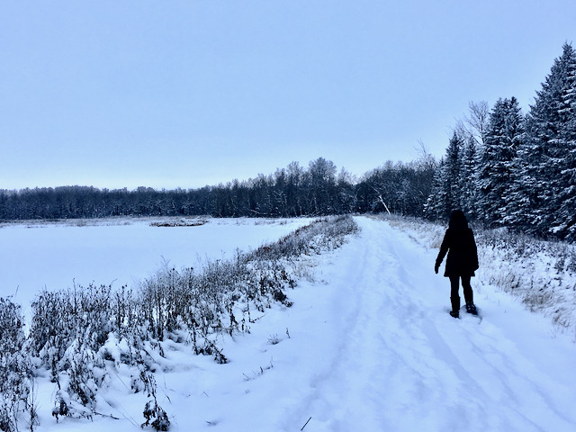
The crunching of snow. Pink cheeks kissed by cold. Your chin tucked into your coziest scarf. Sun shimmering off the snow through the trees. There’s nothing like being fully cocooned in your best outdoor gear on a brisk winter walk to tap into that paradoxical feeling of spaciousness.
While some may think of the Whiteshell or the Forks as memorable Manitoba destinations, southeastern Manitoba holds a highly underrated magic. You can’t really get a sense of it driving through on the highway.
You have to feel the energy rising from the soil.
The landscape is different every single day, her moods a shifting Venn diagram of connection between the daily whims of the earth, the thousands of species of tiny plant & wild-life she supports, and the ever-playful wind and sky. So much life is packed into every nook & cranny of the land in southeastern Manitoba. You have to get right into it to notice.
It was an obvious choice to lean on the expertise of my friend & local writer, Erin Koop-Unger, to pull back the curtain on the secrets of southeastern Manitoba walks. Erin and I met in junior high and spent time roving these backroads with our friend Tilly, before life took us to different schools. I remember a feeling of freedom from our shenanigans back then, a rare sense of being gloriously uninhibited with the two of them in a way I couldn’t elsewhere. One especially hilarious barn-loft sleepover sticks in my memory, with Erin and I staying up in the straw long into the night as Tilly slept beside us.
That sense of delight has popped up for me every time our paths have crossed since I moved back here in 2016. I know Erin to be thoroughly curious and delighted by life. An avid traveler and lover of detail & history. A good question-asker. Full of local expertise, after having spent her life loving the history and community of this place just as much as she loves touring new destinations. Check out her blog, Mennotoba for an intimate peek into all kinds of local charms.
Erin spent the pandemic walking these acres in almost any weather. “It’s an exercise of being in place.” she says. “Being where you are, paying attention, observing what’s around you and appreciating how it may change from day to day – small changes, maybe, but that’s also the point.”
She filled her Instagram grid with photos of oak and poplar and Manitoba maple, trails and back lanes. And always the generous prairie sky peeking in to check on her. Her footsteps through each photo stitched them into a patchwork quilt, a witness to showing up for each day, however it decided to present.
You can channel your inner Erin, too, by exploring her three favourite local winter walks as part of everyday life at Painted Turtle Lake Retreat. While there’s always the option to wander the neighbouring Quarry Oaks Golf Course right outside your door (a winter treat only!), today we’re stepping a little farther out, getting to know the southeastern landscape that holds this place.
All of these walks explore Treaty One territory, which are the original lands of the Anishinaabeg, Cree, Oji-Cree, Dakota, and Dene peoples, and Homeland of the Métis Nation. As settlers here, we practice living with the land by honouring this history and living in reciprocity with First Nations where we are able. If you benefit from Treaty One land, please consider supporting Indigenous-led projects in return, such as the Clan Mothers Healing Village.
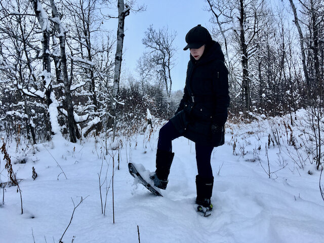
You’ll need to be prepared to meet the stiff Manitoba weather for these winter walks, so be sure to check the weather forecast ahead of time so you can anticipate the state of the trails & bring the right outdoor gear before you arrive. To up your winter walking game, consider investing in a pair of snowshoes to give yourself that extra ease while trekking through the snowdrifts.
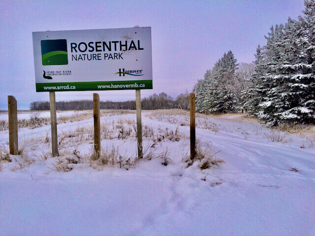
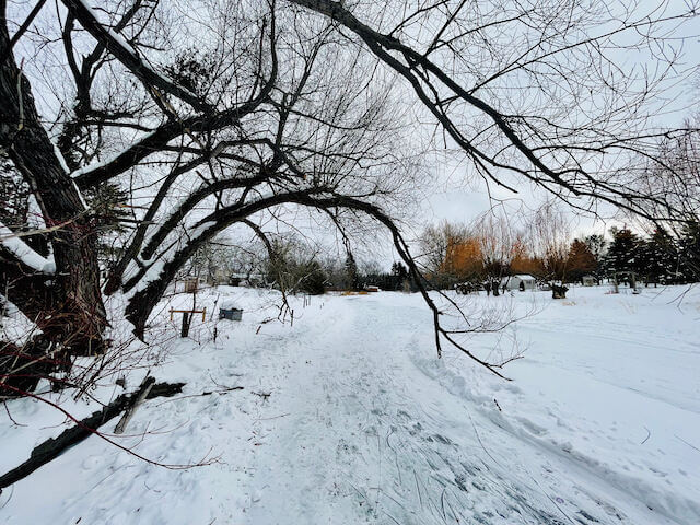
Rosenthal Nature Park
Length: 0.8 miles / 14 mins Difficulty: Easy Distance from Painted Turtle Lake Retreat: 13 km / 16 min drive
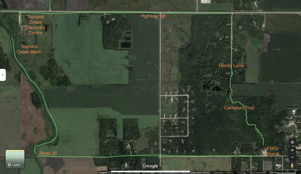
Tourond Creek
Length: 1.4 - 5-ish miles, depending on your adventure level Difficulty: Easy to Hard, it’s your choice! Distance from Painted Turtle Lake Retreat: 24 km / 21 mins
Seine River Walk
Length: approximately 1 mile, maybe a little more, there and back Difficulty: Moderate Distance from Painted Turtle Lake Retreat: 19 km / 15 mins
Rosenthal Nature Park
Length: 0.8 miles / 14 mins
Difficulty: Easy
Distance from Painted Turtle Lake Retreat: 13 km / 16 min drive
Find it on AllTrails: Rosenthal Nature Trail
Location
From Painted Turtle Lake Retreat, you’ll drive through Steinbach and head west on Highway 52. Pass right through the town of Mitchell and turn north (right) on Road 30E where the meridian ends at the west edge of Mitchell. Take Road 30E for a mile and then turn left. You’ll see the woods, and just a short drive down you’ll see the sign saying Rosenthal Nature Park.
There’s enough room at the trailhead for one or two cars to park and it’s never that busy.
Overview
Rosenthal is only a short drive away; it’s easy to access and the environment is really cool. There are woods, there is water, the path is well maintained, and you drive right up to it. It’s quite nice and has a lot of different features in a small area.
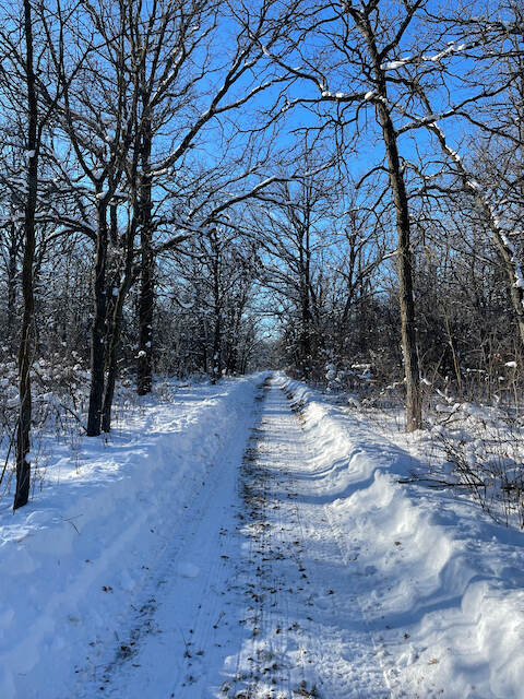
In the summer it’s a smooth, accessible trail, but in the winter it doesn’t get cleared so you’ll need the physical ability to navigate the snow. The municipality recently built a sidewalk connecting Rosenthal to Mitchell, so you could even extend your walk to explore more of the area if you’d like. It would be a great place to bring the snowshoes.
The water feature there is a project of the Seine Rat Roseau Watershed District. You can browse their website to learn more about southeastern Manitoba conservation work.
Memorable Moments
“I love the anticipation of approaching the woods and walking directly into the woods.” Erin says with glee. “And just every part of walking through the woods, of course, then you see you’re coming out of the woods and then you are looping around to the water. And you walk out on a peninsula they’ve made through the middle of the water. Obviously it will be frozen in the winter.”
There are benches to sit on at the end of the loop, so if the weather’s nice and you sit still enough you can observe wildlife. It’s an invitation to slow down and connect with Manitoba’s rural magic.
Erin often times her walk according to what time the sun is rising or setting, just check your weather app for the exact time. “Maybe I’ll try to get there before the sun rises in the morning, or the evening before it sets, just to be out there and see that.” Rosenthal is a fantastic place to watch the sunset from.
Tourond Creek
Length: 1.4 – 5-ish miles, depending on your adventure level
Difficulty: Easy to Hard, it’s your choice!
Distance from Painted Turtle Lake Retreat: 24 km / 21 mins
Find it on AllTrails: Tourond Creek Discovery Centre Loop. This AllTrails link describes only the Discovery Centre Loop. Check out the hand-drawn route below to get a birds’ eye view of the entire Tourond Creek experience!
Location
Tourond Creek is located southwest of Painted Turtle Lake Retreat, also off Highway 52 just a couple of miles west of the junction to Highway 216.
The creek runs beside the Tourond Creek Discovery Centre. You can make several choices for walks at Tourond Creek.
- Check out the Discovery Centre’s website (above) for all kinds of interesting activities and a map for their easy 1.4 mile trail.
- Or you can take what Erin and I have dubbed The Adventurer’s Route, getting down and dirty with the back roads of southeastern Manitoba!
- If the entire Adventurer’s Route is too much, you can park at the Tourond Creek Discovery Centre and take as much of the route as you like before turning back. Each part of the Adventurer’s Route can be enjoyed separately depending on your comfort level, so I’ve tried to lay it out in pieces to help you plan (see map). You can also park at the church cemetery and access just the Cemetery Trail that way.
Overview
Every spot is special on the Adventurer’s Route. Following the berm along the creek is fantastic, just keep in mind it could be terribly muddy. The woods flanking Road 35 and the Cemetery Trail and Honey Lane are all sweet. Walking along the ditch along the highway to get back to your car is a rough way to end the walk, to be honest, but if you like adventure it’s absolutely worth it.
Make sure to bring the right footwear for the weather and an extra plastic bag for your boots afterwards. If it’s muddy you will want to change footwear before driving back. If the weather is bad, the route is going to be very challenging. If you like to power through, you’ll feel really good about yourself afterwards!
Memorable Moments
Tourond Creek Berm
The Adventure Route starts by trekking south along the creek on the berm that runs alongside it. It’s likely to be really muddy if the weather is warm enough so be prepared. You might wonder if you’re allowed to be following the berm out in the middle of the field but it’s ok, as long as you respect the land and leave no trace. You can turn around and go back to your car whenever you like, of course, but Erin likes to follow the berm all the way south to Road 35, about a mile of walking before you get to the next leg of the route.
Road 35
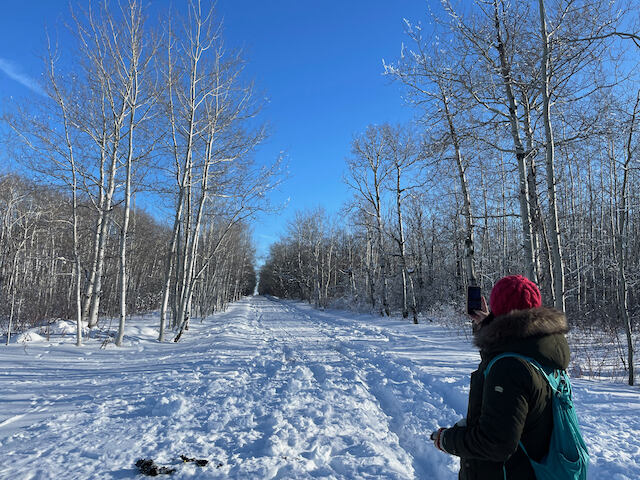
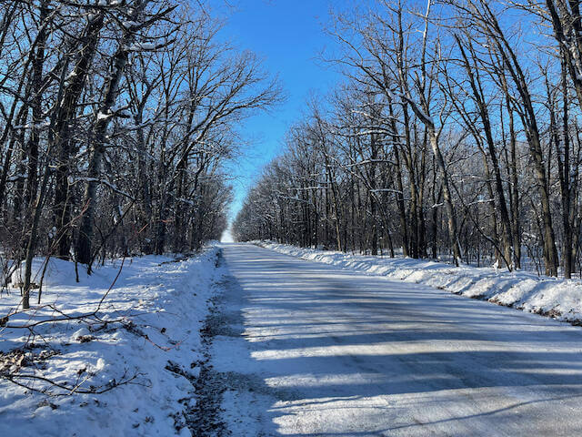
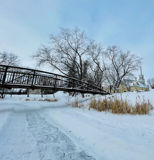
Road 35 is a dirt road with a paved ford where the creek runs over it. At the ford you turn east (left) on the road. After walking a few minutes, you suddenly get to a wooded area. The road is lined with trees and it’s just one of the most fantastic spots to walk through. Locals will head there in the summer, girls in dresses taking Instagram photos, and it’s a beautiful place to catch a sunset. You just keep walking down that road, through all the pretty woods. After another half a mile past a field on one side, you’ll reach the Kleefeld EMC church.
The Cemetery Trail
Through the church grounds you’ll find a gate with a trail into the woods through the church cemetery. This trail winds through the woods on private lands, the Peters’ land. They have generously allowed the public trail on their land so please be extra respectful, stay on the trail and leave no trace. Follow it north all the way through.
Honey Lane
The Cemetery Trail ends up at Honey Lane, running north towards the highway. It’s a very nice lane and you keep following that north for a few minutes until you reach the highway.
Highway 52
Once Honey Lane reaches Highway 52, you’ll turn left and follow the highway back to the Discovery Center parking lot to find your car. Please walk in the ditch as it’s not safe to walk on the highway shoulder.
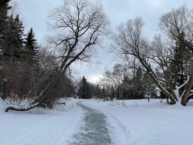
Seine River Walk
Length: approximately 1 mile, maybe a little more, there and back
Difficulty: Moderate
Distance from Painted Turtle Lake Retreat: 19 km / 15 mins
Find it on Google Maps: Redemptoriste Park
There’s something amazing that you can do in Manitoba in winter on a walk that you can’t do any other time, and that’s walk on water! Creeks make amazing paths if they’re safe. If it’s cold enough. And especially if somebody has already been there to break a trail for you, it’s just perfect.
Location
The Seine River Walk starts at the Redemptoriste Park in Ste. Anne, about 15 minutes straight north of Painted Turtle Lake Retreat. The most scenic way to Ste. Anne from the Retreat is to head north through Giroux on Highway 210. Park at Redemptoriste Park and find your way down the bank of the Seine River.
Overview
The river path itself is fairly smooth, although it won’t be groomed for walking. There is no path to get in or out of the river, which raises the trail difficulty up to moderate. This is best for folks with the ability to scramble a bit up and down the slope. A lot of people take this walk though, so there will be a path worn down to the river.
You may need snowshoes depending on the quality of the snow and the seriousness of your boots. Please remember to walk beside the groomed skating trail so as not to damage it for skaters.
Once you get to the edge of town, maybe about 1/2 a mile or a little longer, the town scenery will fade and you’ll likely want to turn back towards your car.
Memorable Moments
The river winds around to offer a nostalgic experience of the town of Ste. Anne. The Villa YouVille, a seniors living complex, is built right over the Seine River. Depending on how tall you are, you may have to duck as you cross underneath their residence. You can also see the Catholic Church from the river, an iconic view that gives you a sense of Ste. Anne’s history.
Erin loves that the walk is so close by and holds a truly unique feel. It’s not an intense workout at all, but you can make it more intense by scrambling up the banks wherever you like, to see what else Ste. Anne has to offer. “You want it to be longer because it’s so lovely,” Erin says. “We think about the walking trails in Winnipeg, like the Forks river trail, but there’s something close by too. I love the small town feel of this walk.”
And there you have it! All three winter walks, each opening up their own portal to a side of southeastern Manitoba that is well worth falling in love with.
Which one are you most excited to try first?
Many thanks to Erin for being our tour guide on these delicious winter excursions.
I’d love to hear your impressions if you get the chance to experience them firsthand, or you can tag us in your photos on Instagram or Facebook @paintedturtlelake.
Make sure to check out our Explore page for a list of other activities, shops & restaurants you can check out as you make Painted Turtle Lake Retreat your home!
Start Your Path Home
Join our waitlist and you'll be the first to know about future openings in our Loft or Studio apartments.
Check your inbox to confirm your name on our list.
Thank you!
You have successfully joined our subscriber list.

Leave a Reply